Tropical Storm Warning: Heavy rain and flooding still NJ’s biggest concern Friday
It's Fay day. As of this writing Friday morning, the northern edge of Tropical Storm Fay is already impacting New Jersey. And it is going to be an overall nasty and miserable weather day.

Fay could be New Jersey's first landfalling tropical cyclone since Irene 2011. (Sandy 2012 was technically extratropical at the time of landfall.) Even more impressive, Tropical storm Fay could make its initial landfall on New Jersey. That has only happened once in history, in 1903!

The Latest on Fay
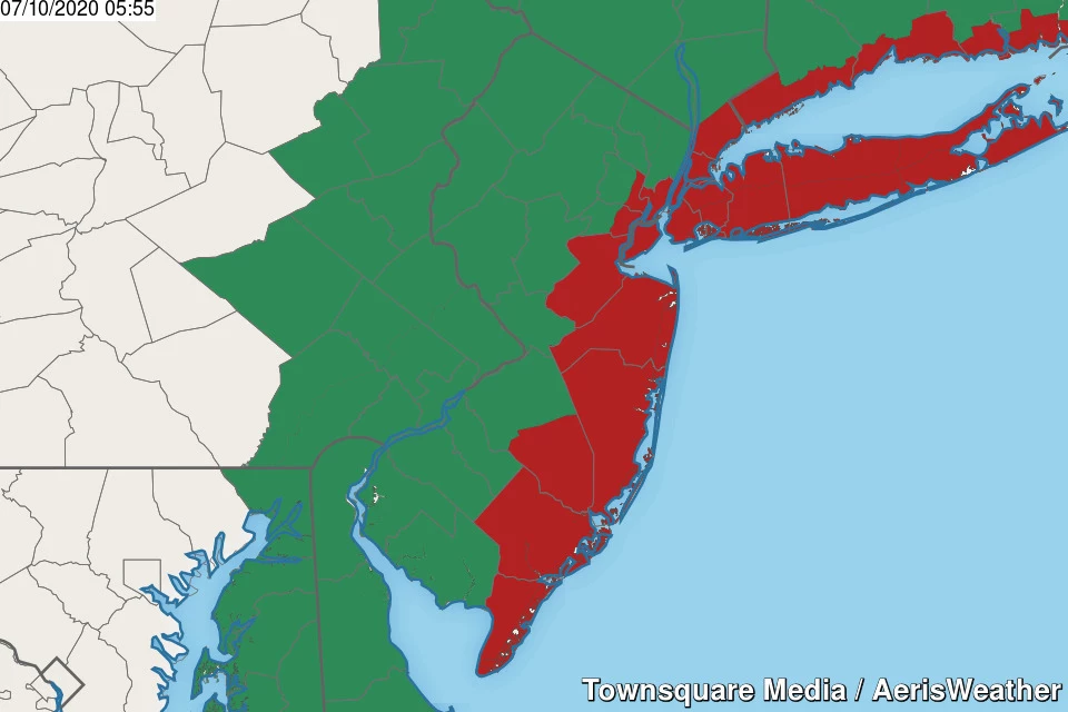
A Tropical Storm Warning (red) continues for the entire Jersey Shore. A Flash Flood Watch (green) is in effect for the entire state of New Jersey — until 4 p.m. for the southern coast, until 8 p.m. for inland New Jersey, and until Midnight for NE NJ.
As of the 5 a.m. update from the National Hurricane Center, Tropical Storm Fay has strengthened slightly. Maximum sustained winds have bumped up to 50 mph. The center of Fay was located 105 miles due south of Cape May, NJ. The storm is crawling north at 10 mph (that forward motion is expected to increase throughout the day).

My latest forecast makes two adjustments, compared to what I have laid out previously:
1.) A slightly later timeline. Rain arrived in South Jersey about 2 hours later than expected. It may not start raining in far North Jersey until Noon Friday. And rain may linger in NE NJ until Midnight Friday night.
2.) Solidifying the storm track. I agree completely with the National Hurricane Center's adjustment of the forecast track, now showing the center of Fay making landfall around Atlantic City Friday afternoon.

Fay Forecast Overview
Let's start with the good news. Any time there's a hurricane or tropical storm in the Atlantic, the Jersey Shore holds their collective breath. But this time around, we get very lucky. Fay is moving quickly, and the period of easterly winds will be brief.
So coastal flooding will be limited to the minor category, if that. (A half-foot to a foot of storm surge.) Our next high tide cycle is coming up around lunchtime on the oceanfront, then this afternoon in back bays and tributaries. Wave heights will only reach about 3 to 4 feet, limiting the threat of beach erosion. And there is a very high risk of dangerous rip currents.
Tropical rainfall is, by far, our biggest concern from Fay. As the blob of heavy rain charges north through Friday morning, rainfall totals will end up between 2 and 3 inches across most of the state. A few spots could shallow up, finishing in the 1 to 2 inch range. Similarly, localized totals of 4+ inches are absolutely a possibility.
That level of rain can easily lead to flash and river flooding. You could face significant travel challenges throughout the day, during both the morning and evening rush hours.
Wind gusts to 30-40 mph (inland) and 40-50 mph (coast) are expected too. That's enough to cause driving difficulties, blow around garbage cans and lawn furniture, bring down some trees and branches, and cause power outages. Not quite tropical storm force. Nowhere close to hurricane strength. Akin to a "windy day".
What to Expect: Region by Region
South Coast... Atlantic, Cape May, Cumberland
—First Raindrops... 2 a.m. (already started)
—Tapering Time... 1 p.m. to 4 p.m.
—Final Raindrops... 6 p.m. to 10 p.m.
—Rainfall Totals... 2 to 4+ inches
—Top Wind Gusts... 40 to 50+ mph
Southwest... Salem, Gloucester, Camden
—First Raindrops... 6 a.m. (now arriving)
—Tapering Time... 2 p.m. to 5 p.m.
—Final Raindrops... 7 p.m. to 10 p.m.
—Rainfall Totals... 1 to 3 inches
—Top Wind Gusts... 30 to 40+ mph
North Coast... Ocean, Monmouth, Middlesex
—First Raindrops... 6 a.m. to 8 a.m.
—Tapering Time... 3 p.m. to 7 p.m.
—Final Raindrops... 8 p.m. to Midnight
—Rainfall Totals... 2 to 4+ inches
—Top Wind Gusts... 40 to 50+ mph
Inland Central... Burlington, Mercer, Hunterdon, Somerset
—First Raindrops... 6 a.m. to 10 a.m.
—Tapering Time... 6 p.m. to 9 p.m.
—Final Raindrops... 9 p.m. to 1 a.m.
—Rainfall Totals... 1 to 3 inches
—Top Wind Gusts... 30 to 40 mph
Northwest...Warren, Morris, Sussex
—First Raindrops... 9 a.m. to Noon
—Tapering Time... 8 p.m. to 11 p.m.
—Final Raindrops... 11 p.m. to 1 a.m.
—Rainfall Totals... 1 to 3 inches
—Top Wind Gusts... 30 to 40 mph
Northeast...Union, Essex, Hudson, Bergen, Passaic
—Start Time... 9 a.m. to Noon
—Tapering Time... 6 p.m. to 10 p.m.
—End Time... 11 p.m. to 3 a.m.
—Rainfall Totals... 2 to 3+ inches
—Top Wind Gusts... 40 to 50 mph
The Extended Forecast
The storm will be long gone as we dive into the second weekend of July. It's just going to be steamy and summery.
As rain ends completely Friday night, skies will clear. It will feel tropical, with high humidity and low temperatures in the lower 70s. Fog is possible by Saturday morning.
Look for a mix of sun and clouds on Saturday. It will be breezy, hot, and humid with inland high temperatures back to near 90 degrees. One or two rounds of late-day thunderstorms are likely. Downpours falling on saturated soil may cause a rapid recurrence of flash flooding.
Sunday should be mostly sunny and dry. It will be hot, and ever so slightly less humid. High temperatures will probably reach into the lower 90s (away from the coast).
There's no relief from the heat on the horizon. The extended forecast shows a chance for 90s along the NJ Turnpike corridor for Monday, Tuesday, Wednesday, and Thursday. Dog days of summer, here we come!
Please be smart and be safe during this Fay day. Our weather, news, traffic, programming, and digital teams will be on-air and online all day with the latest New Jersey centric info on the storm. See you on the other side — have a great weekend.
Dan Zarrow is Chief Meteorologist for Townsquare Media New Jersey. Follow him on Facebook or Twitter for the latest forecast and realtime weather updates.
More From SoJO 104.9 FM