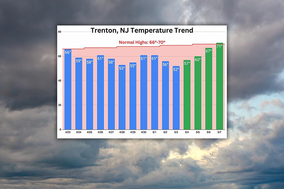
Thursday will be New Jersey’s 11th unseasonably cool day in a row
The Bottom Line
Look, below-normal temperatures are not necessarily a bad thing. Variety is the spice of life, right? And a natural part of weather and climate. Remember: A "normal" temperature is a long-term average, finding a middle-ground between warm and cold.
I would much rather endure temperatures 15 degrees below average than 15 degrees above average. (Except, perhaps, in the dead of winter.)
However. We have been stuck in a cool weather pattern for over a week and a half now. And our skies and weather have not completely cleared out from the weekend washout. We are craving sunshine and warmth.
We will see slow improvements for Thursday and Friday. But there will be a few showers around. And temperatures will remain very much on the cool side.
And then — finally — the light at the end of the tunnel. Beautiful weather will settle into New Jersey for the weekend.

Thursday
The atmosphere starts moving again Thursday, as the stagnant storm system over the Great Lakes starts its shift out ot sea.
The bad news: We are starting the day with a blanket of clouds. Temperatures will still end up 10 degrees below normal. And there will be some showers in the Garden State.
However, there is some good news too: There will be more breaks of sun than the past few days. Thursday's temperatures will be a few degrees warmer than Wednesday's. And raindrops will be hit or miss.
You'll want a jacket again Thursday morning, with temperatures in the 40s across the entire state. Highs will reach about 55 to 60 degrees Thursday afternoon.
Look for mixed clouds and pockets of sun. As of this writing (6:30 a.m.), a band of showers is clipping northeastern New Jersey. Additional popup showers and even a little thunderstorm are expected around the midday to afternoon hours.
That shower chance will continue into Thursday night too. Under partly cloudy skies, temperatures will once again plummet deep into the 40s by Friday morning.
Note #1: There are still a couple of Flood Warnings posted for the Passaic River in North Jersey. Water levels are still running high and fast there. I doubt Thursday's shower activity will be enough to exacerbate the flood risk again. But it's something to watch.
Note #2: Speaking of flooding, the Jersey Shore could see several rounds of spotty minor tidal flooding over the next few days. Especially along back bays and tributaries. The water rise is not quite enough to ring big alarm bells. But vulnerable spots along the coast could see some water. The evening high tide cycles will be most precarious, from Thursday through Sunday.
Friday
Partly sunny and near 60 degrees. Not terrible.
Friday will also bring one more shot at isolated showers and rumbles of thunder, again primarily from midday into the afternoon.
By the end of Friday — less than 36 from now — we will be able to celebrate the end of this stretch of unsettled weather.
Saturday
No complaints whatsoever. Skies should become mostly sunny by lunchtime. And rain chances are pretty much zero.
High temperatures on Saturday will shoot into the upper 60s. Very close to seasonal norms for early May.
Sunday
Even better than Saturday, perhaps. A few fair-weather clouds will come into play for the second half of the week. But we will stay dry and seasonably mild.
Look for highs in the lower 70s. New Jersey's warmest day since April 22.
The Extended Forecast
We will hold on to sunshine and 70s for Monday, another dry weather day. And then things go off the rails a bit, as rain comes into play on Tuesday. I suspect Tuesday will still be on the warm side. (Some models even should some 80s in South Jersey.) Even if we cool down through the middle of the week, it will not be as pronounced nor as prolonged as our most recent chill-out.
Dan Zarrow is Chief Meteorologist for Townsquare Media New Jersey. Follow him on Facebook or Twitter for the latest forecast and realtime weather updates.
NJ county fairs are back! Check out the 2023 summer schedule
Cape May, NJ: 15 wonderful places to visit
More From SoJO 104.9 FM
