Nor’easter update: Heavy snow, power outages, major flooding expected
The snow forecast remains mostly unchanged, with a large area of New Jersey expecting over a foot of accumulation alongside other weather and coastal issues.
Meteorology Model Mania!
I'm pretty pleased with the looks of this morning's model run... The GFS has trended snowfall amounts down slightly for New Jersey and the Euro shifted south slightly. The GFS and European ensemble output, in particular, match well with the "first stab" forecast map we published yesterday.
Meanwhile, the NAM went off the deep end, with a sudden shift to 3+ feet snowfall for the middle half of New Jersey. Yikes. But let's not panic just yet, please... Since this solution is such an outlier compared to all other models, I think it's prudent to just ignore the NAM for now... If it continue to show this blowout heavy snow forecast consistently over the next 2 to 4 runs, that will warrant a raised eyebrow or two.
Yes, I do research forecasts from other media outlets and meteorologists... And I'm pretty comfortable where I sat with yesterday's forecast. While I've seen other meteorologists make major changes to their going snow forecast this morning, based on the latest models, I opted to make only two tweaks to our snow map today...
Tweak/Issue #1: Rain-Snow Line
I remain somewhat puzzled over the chance for our snow to partially or totally transition to rain along the Jersey Shore. I have a high temperature forecast of 34 at Belmar and 39 at Atlantic City on Saturday. Additionally, I've seen models suggest that even temperatures about a mile above the surface could also climb above the freezing mark... Such a pool of relatively "warm" air at the surface would certainly sufficient to sustain a prolonged period of rain rather than snow.
That presents a big problem: Exactly how far inland will that rain-snow line drift?
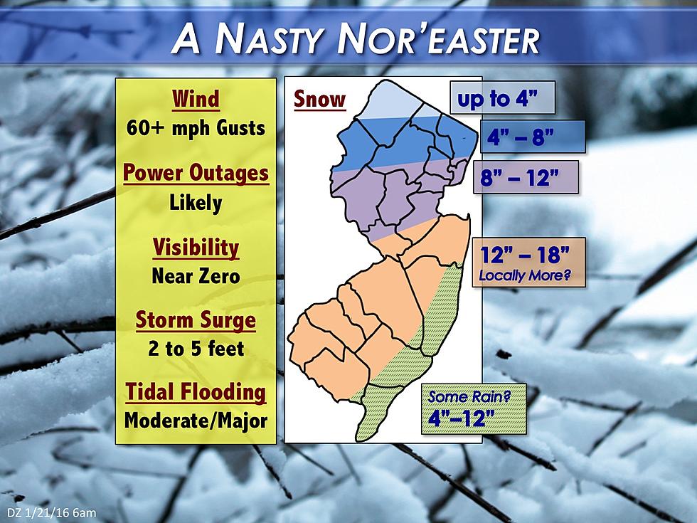
Words cannot even describe the forecast difficulty for areas of New Jersey that lie just a little bit inland, such as Holmdel, Freehold, Lakewood, Toms River, Hammonton, and Vineland. Will it be 2 or 12 inches of snow? Or more? I've presented my best guess on the latest forecast map above... My best advice for residents of Monmouth, Ocean, Atlantic, and Cape May counties would be to prepare for double-digit snowfall. But don't be surprised if there's a lot of rain there too.
Tweak/Issue #2: Mesoscale Snow Bands
Our nor'easter is going to have a lot of energy swirling around within itself, so I expect numerous bands of "1+ inch an hour" snowfall.
However: Exactly where will those small-scale, isolated, very heavy snow bands set up?
It's nearly impossible to answer that question with high confidence or accuracy before the storm gets here. Model run after model run has put New Jersey's snow "bullseye" in the southwest corner of the state - so the area around Salem, Cumberland, Gloucester, Camden, and Burlington counties is most likely to experience the best storm dynamics and hardest-hitting snowfall overall.
Yesterday's map called for "12+ inches" of snow for inland portions of central and southern New Jersey. I refined the map key to read "12 to 18 inches" instead, and also added wording that suggests "Locally More?"... Even though this morning's model suite trended downward slightly in overall snowfall potential, I remain fairly confident of a widespread area of double-digit totals. Meanwhile, I wouldn't surprised to ultimately see a few spots higher than 18 inches within the orange-colored band.
Winter Storm Forecast Rundown
--Snow: As the snowfall forecast map shows, a large area of 12 to 18+ inches of snow accumulation is expected for inland portions of central and southern New Jersey. Along the coast, periods of rain may lead to reduced overall snow totals. (But again, there remains great uncertainty over how far west the rain-snow line will drift during the storm.) I'm forecasting a wide range of 4 to 12 inches along the Jersey Shore. Northern New Jersey will also see lower snowfall totals, as that area will be on the northern edge of the storm track.
--Coastal Flooding: Moderate to major flooding of tidal waterways (including oceans, back bays, lagoons, etc.) is anticipated from this nor'easter. Storm surge of 2 to 5 feet is likely - so I recommend you look at the water level at today's high tide and visualize it about 5 feet higher to get a sense for the impact of this kind of surge. While the flooding is not expected to reach the severity of Superstorm Sandy, this nor'easter could very well become a "top 10" and maybe even "top 5" flood crest for tidal gauges up and down the coastline. That kind of water inundation is quite significant.
--Beach Erosion: The peak ocean wave forecast has come down slightly this morning. However, with 14 to 17 foot waves just off the Jersey Shore, beaches will be battered and will probably lose a lot of sand to the sea.
--Winds: During the peak of the storm, sustained northeasterly winds of 25 to 35 mph are expected statewide. Gusts over 60 mph will be possible, especially along the coast. Such strong winds are apt to cause downed trees and some property damage. It would be wise to secure lawn furniture, leftover holiday decorations, etc. before the storm hits. Power outages are likely as well, which will be especially hazardous as wind chills fall to about zero during the peak of this winter storm.
--Visibility: The combination of snow, rain, and wind will reduce visibility to near-zero. Obviously, travel will be incredibly difficult, if not impossible.
--Advisories: As of this writing, a Blizzard Watch is in effect for Union, Essex, and Hudson counties in northeast New Jersey (along with New York City and Long Island) from Friday night through Sunday morning. A Winter Storm Watch has been issued for the rest of New Jersey. And a Coastal Flood Watch is out for coastal Monmouth, Ocean, Atlantic, Cape May, and Cumberland counties. These watches will likely be upgraded to warnings on Friday.
--Timing: First snowflakes will affect far South Jersey on Friday evening... Storm intensity picks up for the calendar day Saturday, with the heaviest rain and snow during the day... The highest surge will probably occur in the evening hours... Snow tapers off by midday Sunday... By late Sunday afternoon, we could actually see sunshine return to the skies over New Jersey. But if the double-digit snowfall forecast verifies, it will take a while to dig out from this winter storm.
I am planning a special blog post with a more specific breakdown of the storm's timeline. That will help you know which plans you need to cancel this weekend, and which events on Friday evening or Sunday may still be OK. Hopefully, I'll have that written and posted by lunchtime today.
The next forecast update and snowfall map will be published late afternoon, by around 5 p.m.
Dan Zarrow is the Chief Meteorologist for Townsquare Media New Jersey. Follow him on Facebook or Twitter for the latest forecast and realtime weather updates.


