NJ weather: Thermometers get cooking again, rain chances fade
The Bottom Line
After an unusually gloomy, unseasonably cool day Monday, summer returns in full blast on Tuesday as the sun comes out again. It will be hot and humid — a full 10 to 15 degrees warmer than Monday.
Tuesday is also a cold front day. That frontal boundary is very weak and moisture-starved, so we're only looking at an isolated shower or thunderstorm. More importantly, humidity will dial back for Wednesday, setting us up for a nice weather day.
In fact, Wednesday looks like the only truly nice day in the forecast. Disgusting, potentially dangerous heat returns on Thursday. Friday looks steamy too.
We had been tracking a chance for some soaking rain late-week, but models are starting to back off that idea. Spotty showers and thunderstorms are still in the forecast through the weekend — but it will be far from the drought-buster we need right now.
Tuesday
It is a nice morning. Temperatures are averaging 70 degrees across the state. We actually had a surprise batch of rain push through South Jersey in the early morning hours, but that has since departed. You may find some puddles and light patchy fog around.
Tuesday will bring a return to heat and humidity. Not the dangerous stuff — just "regular" summertime weather.
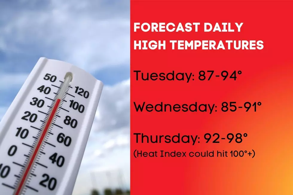
Look for highs in the lower 90s across most of the state. The southwest breeze may very well negate the sea breeze machine, so even mainland beaches will be hot. Skies will be bright, a mix of sunshine and passing clouds.
A cold front will drive through New Jersey, from north to south, Tuesday afternoon and evening. That frontal boundary will be pretty weak and moisture-starved. We could see a few very spotty showers and thunderstorms pop up, especially in North Jersey. But once again, most of the state will stay high and dry.
Behind the front, Tuesday night will be fairly comfortable, clearing to mainly clear skies. Lows should dip into the upper 60s across northern NJ and lower 70s in southern NJ.

Wednesday
The only truly "nice" day left in the forecast. We will be treated to lower humidity, which is always a nice treat in the middle of summer.
Wednesday will still be very warm, with highs in the upper 80s to around 90. It will be a mostly sunny, dry day. And the Jersey Shore should benefit from a prominent sea breeze, keeping beaches cooler in the afternoon.
All around sounds like a great day. Enjoy it!
Thursday
Thursday will not be a nice day, as bigtime heat and humidity surge again. It's going to be disgusting. And even downright dangerous, if you don't take care of yourself.
High temperatures on Thursday will soar into the mid to upper 90s. (At least — 100 degrees is still in play.) As dew points hover near 70, it's going to be quite humid too. So the heat index will most certainly surpass the triple-digit mark in spots Thursday afternoon.
With blazing sunshine overhead, pavement, cars, and non-air-conditioned spaces will be pretty brutal by Thursday afternoon. I expect heat advisories and warnings to be posted for this day, assuming the forecast holds firm.
Friday & Beyond
Things have shifted a bit late-week, and not in a good direction.
Friday will still be steamy, with highs well in the 90s. (I'm keeping that description intentionally vague, as I do not have a good sense yet whether it will be lower 90s or upper 90s.)
While we had been talking about soaking rain to end the first week of August, that frontal complex now looks to get "stuck" just before entering New Jersey. I'm sure it will still spit some spotty showers and thunderstorms at us in the Friday afternoon to evening time frame. But it's not the thorough soaking we need right now. Rainfall totals will be on the order of a half-inch, rather than upwards of two inches.
The first weekend of August is trending hot, with highs near 90 on Saturday and in the lower 90s on Sunday. Humidity will most certainly be present, so you will most certainly sweat a lot.
Both weekend days will also provide a chance for late-day spotty showers and thunderstorms. While that will give us an opportunity to (temporarily) cool down, raindrops may affect your outdoor plans. Just know that these rain chances are likely to be very much hit-or-miss — just like every other thunderstorm threat this summer. So don't go canceling weekend plans yet.
The heat and humidity will probably continue until the middle of next week, when a strong cold front drives in rain and then cooler, less humid air. Long-range models paint a cooler-than-normal middle of August, with more temperatures in the 70s and 80s rather than 90s and 100s.
Dan Zarrow is Chief Meteorologist for Townsquare Media New Jersey. Follow him on Facebook or Twitter for the latest forecast and realtime weather updates.
Why do cats have whiskers? Why do they meow? Why do they nap so much? And answers to 47 other kitty questions:
Gallery Credit: Andrew Lisa
LOOK: Here are the pets banned in each state
Gallery Credit: Elena Kadvany
More From SoJO 104.9 FM


