
NJ weather: Rain wraps up, midweek storm looks both wintry and wet
The Bottom Line
We are in the midst of our fifth storm system of the month of January so far. Each one of them predominantly a rain maker. Although we did have some light accumulations on Sunday in North Jersey, up to a half inch.
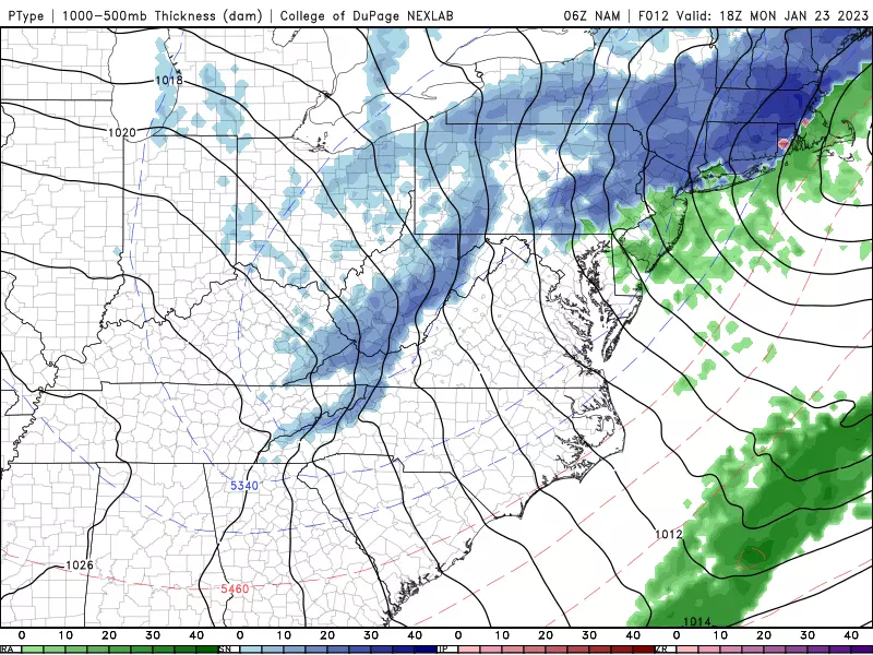
Our latest weathermaker will still be with us for most of Monday, with waves of rain and drizzle. In addition, one final flip to wintry mix is possible for North Jersey, which may lead to slushy spots.
The sixth and final storm system of the month is coming up on Wednesday. And this is the most interesting of the bunch — likely our best chance of accumulating snow in almost a year.
It will not be a "major" storm by any means. But a few inches of accumulation during the daytime hours on Wednesday, away from the coast, could lead to some tricky travel troubles.
Cold, generally quiet weather then settles in until the first day or two of February.
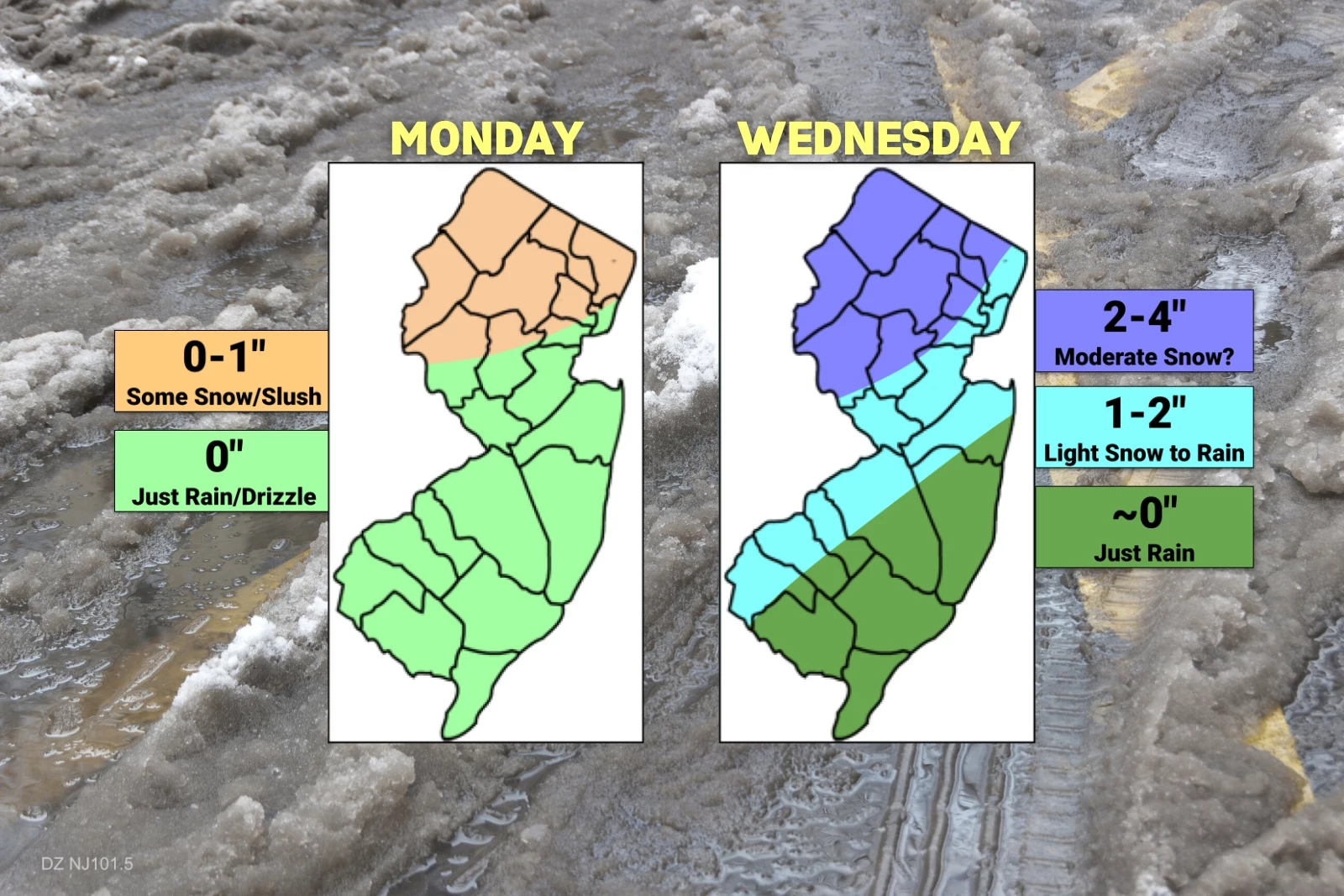
Monday
A half-inch of rain and up to a half-inch of snow make for a lousy finish to the weekend. And we start the workweek the same way, with lingering rain, drizzle, and fog.
This coastal low will stay with us for most of Monday, so I have to keep raindrops in the forecast until sometime in the afternoon. (Likely ending early afternoon for South Jersey, late afternoon for North Jersey.) An additional quarter-inch of rain is possible.
There is also a good chance that areas of North Jersey will briefly flip back to snow or wintry mix for a few hours. Geographically, we're talking about the usual area north of Interstate 78. Even though the ground is wet — and therefore pretty warm — there could be some slushy spots by this afternoon. Just be careful.
One more concern for the morning hours: Coastal flooding. As this storm system churns up the ocean a bit, guidance shows tide levels popping just barely above flood stage. It's enough to cause high water issues for the most vulnerable spots, in the "minor flooding" category. A Coastal Flood Advisory is posted for the Jersey Shore from 7 a.m. to 1 p.m. Monday.
As rain winds down Monday afternoon, this area of low pressure will start to drag cold air down into New Jersey. You'll feel a brisk wind blowing out of the northwest, gusting to 30 mph. Temperatures may slowly push downward through the afternoon, after reaching a high of only about 40 degrees.
Clouds will break apart Monday night, with a low temperature around 30. A little breeze will add a bite to that cold air, sending wind chills deep into the 20s overnight.
Tuesday
A dry, quiet weather day. It will be partly sunny, but blustery as a westerly wind blows in the "breezy" category. Look for highs in the mid 40s — not bad for the "dead of winter," late January.
Wednesday
Here comes our next storm system. And it looks both complicated and potentially messy. Although I do want to stress it is not currently shaping up to be a "major" winter storm.
It all begins between mid-morning and midday on Wednesday. Our latest forecast suggests that temperatures will likely be cold enough for a few hours of snow and/or icy mix. Especially away from our coastal counties — along and north of I-195, and along and west of I-295.
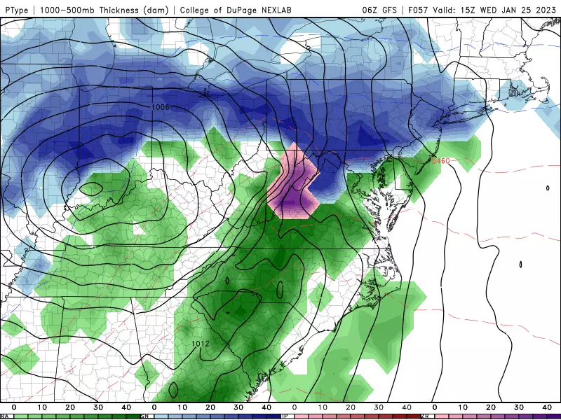
Areas to the north and west could even see "a few" inches of accumulation, on the order of 3 or 4. That's enough to cause some tricky travel troubles Wednesday, especially given the middle-of-the-day timing. If this forecast holds, I fully expect to see advisories issued for most of the state once it gets closer.
Warmer air will penetrate our atmosphere Wednesday afternoon, forcing a transition to all rain. Yes, all 21 counties of New Jersey should flip from wintry to just wet by Wednesday evening. Temperatures will eventually push into the 50s Wednesday night, with pockets of heavy rain possible.
Note: We are still 48 hours away from first flakes, which leaves plenty of room for this storm track to "wiggle" and evolve. The impacts here are very much temperature dependent, which makes the forecast even more shaky. We will keep you updated regularly on the latest forecast updates, all the way through Wednesday's sloppiness.
Thursday
Rain should wrap up in the pre-dawn hours of Thursday, before skies start to clear during the day. As you might expect, a brisk wind will kick up too, sending temperatures tumbling. While Thursday will start in the 50s, we'll be in the 40s (or even some 30s) by late afternoon.
The Extended Forecast
Quiet weather settles in for the final weekend of January. Friday will be seasonably chilly, with highs only around 40. Sun and clouds and 40s for Saturday. Turning cloudy Sunday, in the 40s, with a chance of late showers. (Probably rain showers.)
Our next opportunity for a storm system of any significance would be right around the 1st or 2nd of February. Still way too early to lean "wintry vs. wet" just yet.
Dan Zarrow is Chief Meteorologist for Townsquare Media New Jersey. Follow him on Facebook or Twitter for the latest forecast and realtime weather updates.
Let it snow: 12 things to know about winter forecasting in NJ
Gallery Credit: Dan Zarrow
First flakes: When does snow season start in NJ?
Gallery Credit: Dan Zarrow
More From SoJO 104.9 FM
