NJ Could See Rain, Wind Associated With Tropical Storm Nicole Later This Week
The Garden State could feel the impacts, in some capacity, of what is now Tropical Storm Nicole by the end of the work week.

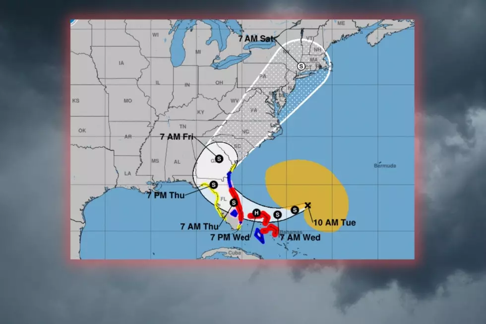
As of 10 AM Tuesday, the center of Tropical Storm Nicole was located about 460 miles east of West Palm Beach, FL, and the storm, with maximum sustained winds of 50 MPH, was moving towards the west at 9 MPH.
According to the National Hurricane Center,
The center of Nicole will approach the northwestern Bahamas today and tonight, move near or over those islands on Wednesday, and approach the east coast of Florida...Wednesday night. Nicole's center is then expected to move across central and northern Florida into southern Georgia Thursday and Thursday night.
Forecasters say Nicole could be near or at hurricane strength as it approaches Florida tomorrow.
Potential impacts for New Jersey
As Nicole makes landfall over Florida, experts believe the storm will then curve towards the northeast, which would bring some unsettled weather our way for Friday afternoon through early Saturday morning.
Depending on exactly where the storm tracks, New Jersey could see some heavy downpours with gusty winds and rough seas.
The center of Nicole is expected to remain over land as it heads up the coast, so residents in the Garden State do not have to worry about a hurricane barreling this way.
As always, forecasts involving tropical storms and hurricanes are subject to change and as the end of the week approaches, we'll have a better idea of Nicole's potential impacts here.
After Nicole, you'll need your winter jacket
Hopefully, you enjoyed those highs in the 70s and 80s this past weekend and Monday because once Nicole moves through, temperatures are going to tumble.

A large section of the country will see sharply colder weather for much of next week.
In our area, high temperatures likely won't get out of the 40s Sunday and Monday with overnight lows below freezing.
KEEP READING: Get answers to 51 of the most frequently asked weather questions...
LOOK: The most expensive weather and climate disasters in recent decades
Gallery Credit: KATELYN LEBOFF
More From SoJO 104.9 FM