What a nasty storm: NJ’s top rainfall totals and wind gusts
For the fourth "weekend's end" in a row, the heavens opened up, pouring rain upon New Jersey. This time around, the culprit was a powerful coastal storm system, which soaked the entire Atlantic seaboard from Florida to Maine. The atmosphere was unusually dynamic, convective, and ... wet.
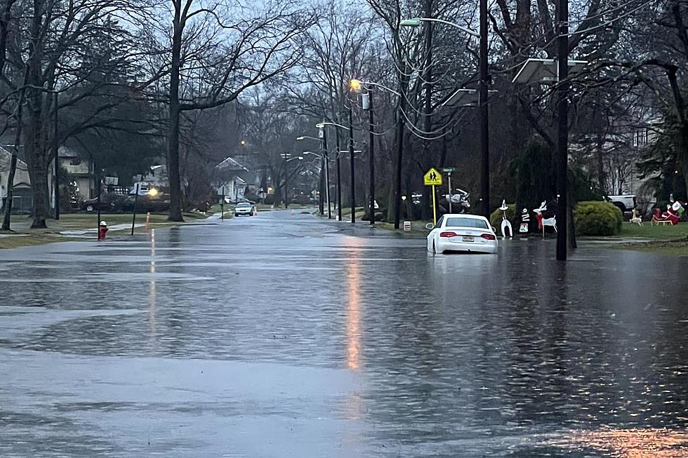
We rang alarm bells for flash flooding, coastal flooding, and gusty winds throughout the weekend. And unfortunately, the worst-case scenario played out. Over 5 inches of rain fell across parts of New Jersey, leading to significant flooding issues during the morning rush hour.
My friend and NJ Traffic North reporter Bob Williams even texted me early Monday morning: "It's really incredible the amount of roads closed today. It's been a while since it's been like this."
Indeed, this may have been New Jersey's worst round of flooding since the remnants of Ida in September 2021. Roads were impassable, schools were delayed or even closed, and morning commutes were snarled.
Meanwhile, at the storm's peak, over 50,000 NJ customers were without electricity. Likely due to the combination of both heavy rain and strong wind gusts.
It was not the wettest day of 2023, but it was close. The top rainfall totals — over four inches — occurred in a narrow stripe through the middle of New Jersey, from the Pine Barrens to the New York State line.
Preliminary, unofficial top storm total rainfall from the NJ Weather & Climate Network and Community Collaborative Rain Hail and Snow (CoCoRaHS), as of 8:30 a.m. Tuesday...
—Long Valley, Morris, County... 5.88"
—West Milford, Passaic, County... 5.42"
—Ringwood, Passaic, County... 5.30"
—Oakland, Bergen, County... 5.24"
—Hammonton, Atlantic, County... 5.12"
—Estell Manor, Atlantic, County... 5.04"
—Wayne, Passaic, County... 5.00"
—Franklin Lakes, Bergen, County... 4.96"
—Caldwell, Passaic, County... 4.85"
—Verona, Essex, County... 4.83"
—Cedar Grove, Essex, County... 4.80"
—Montville, Morris, County... 4.75"
—Wayne, Passaic, County... 4.75"
—Pompton Lakes, Passaic, County... 4.68"
—South River, Middlesex, County... 4.62"
—Oak Ridge Reservoir, Passaic, County... 4.60"
—North Haledon, Passaic, County... 4.55"
—Little Falls, Passaic, County... 4.54"
—Vernon, Sussex, County... 4.53"
—West Caldwell, Essex, County... 4.51"
—Mahwah, Bergen, County... 4.50"
—Pequannock, Morris, County... 4.50"
—Turnersville, Gloucester, County... 4.42"
—Parsippany, Morris, County... 4.41"
—Mullica Township, Atlantic, County... 4.36"
—Ramsey, Bergen, County... 4.29"
—Livingston, Essex, County... 4.26"
—Green Brook, Somerset, County... 4.26"
—Lincoln Park, Morris, County... 4.24"
—Picatinny Lake, Morris, County... 4.22"
—Chatham, Morris, County... 4.14"
—Basking Ridge, Somerset, County... 4.13"
—Rockaway, Morris, County... 4.12"
—Mine Hill Township, Morris, County... 4.11"
—Cream Ridge, Monmouth, County... 4.04"
—Montclair, Essex, County... 4.02"
The lowest rain totals were right along the Jersey Shore — somewhat unusual for a "coastal storm". Having said that, every spot in New Jersey had at least one report of one and a half inches of rain. 10 counties had at least one 4+ inch report, as listed above.
Meanwhile, the strongest wind gusts were generally along the coast. However, a few inland places briefly gusted above 50 mph.
Preliminary, unofficial top measured wind gusts from the NJ Weather & Climate Network and National Weather Service as of 8:30 a.m. Monday...
—Brigantine, Atlantic County... 62 mph
—Seaside Heights, Ocean County... 61 mph
—Lower Alloways Creek Township, Salem County... 56 mph
—Tuckerton, Ocean County... 56 mph
—Belmar, Monmouth County... 55 mph
—Harvey Cedars, Ocean County... 53 mph
—Logan Township, Gloucester County... 53 mph
—Lyndhurst, Bergen County... 53 mph
—Manasquan, Monmouth County... 53 mph
—Manchester, Ocean County... 54 mph
—Sea Girt, Monmouth County... 53 mph
—Atlantic City, Atlantic County... 52 mph
—Fortescue, Cumberland County... 52 mph
—North Beach Haven, Ocean County... 52 mph
—Millville, Cumberland County... 51 mph
—Little Egg Harbor Township, Ocean County... 50 mph
Coastal flooding was also an important impact of the storm, with many tidal water gauges exceeding flood stage. One more round of minor category water rise is expected around midday Monday.
Wintry weather was never a concern here, as temperatures reached into the 60s. Spots including Cream Ridge, East Brunswick, Fort Dix, and New Brunswick hit 64 degrees early Monday morning. Very close to record high temperatures for the 18th of December.
The worst of the storm is over, although pockets of rain will continue to dampen the Garden State through early Monday afternoon. The next week features dry weather, leading up to the weekend, Christmas Eve, and Christmas Day.
Dan Zarrow is Chief Meteorologist for Townsquare Media New Jersey. Check out Dan's weather blog or follow him on Facebook for your latest weather forecast updates.
LOOKING BACK: Incredible, heart-breaking images of Ida's damage
Gallery Credit: Dan Alexander
LOOK: The most expensive weather and climate disasters in recent decades
Gallery Credit: KATELYN LEBOFF