
Two tropical threats NJ needs to watch closely this week
The Bottom Line
As New Jersey basks in beautiful weather on this penultimate weekend of the summer season, there are two storms brewing in the Atlantic basin that are being monitored closely.
Hurricane Franklin is churning through the open Atlantic between the Bahamas and Bermuda, and will fly past the U.S. East Coast early this week.
Newly-upgraded Tropical Storm Idalia (formerly known as Tropical Depression #10) is driving rain and wind through the Yucatan Peninsula of Mexico and the western coast of Cuba. The current forecast track shows the storm striking the Gulf Coast of Florida as Hurricane Idalia midweek, before potentially sliding our way late week.
While neither of these two storms are expected to have serious direct impacts on New Jersey, they may still affect our surf and sky. We're talking about rough surf and rip currents. Along with enhanced cloud cover and humidity. And possibly some rain and wind.
There is already a lot of hype swirling around the internet about Franklin and Idalia. I want to get ahead of any misinformation and panic by offering a calm, detailed explanation of what could happen here this week.

Non-Tropical Rain Storm
Before we talk about tropical weather, I do want to mention our next round of unsettled weather. A few showers are forecast to arrive in the Garden State Monday afternoon, continuing as periodic thunderstorms on Tuesday and Wednesday.
Again, this inclement weather is not directly related to Franklin and Idalia. (Although there may be a connection between our atmosphere and those deep pools of tropical moisture.)
The big concern here is for a batch of heavy rain between late Monday and early Wednesday. The NAM forecast model has been pretty bullish, showing several inches of total rainfall. I think a more reasonable expectation is an inch-plus in the wettest spots only. Still pretty healthy rainfall, limiting prospects for a beach day on Tuesday in particular.
By Wednesday afternoon, a cold front will sweep out the rain and (hopefully) deliver a shot of cooler, drier, refreshing air. While we originally believed those super-nice conditions would last into the Labor Day Weekend, Idalia has other plans.
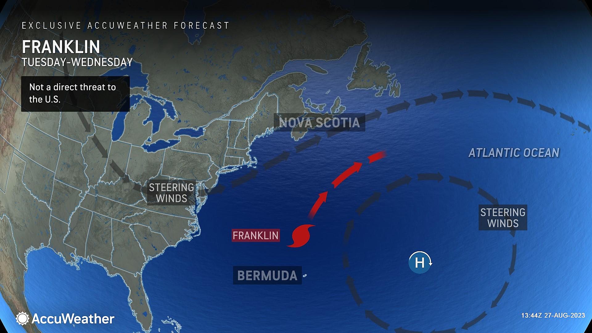
Hurricane Franklin
As of this writing (11 a.m. Sunday), Franklin is a category 2 hurricane with maximum sustained winds of 100 mph. The storm is currently centered about 300 miles northeast of the Turks and Caicos Island. Or about 1,000 miles southeast of New Jersey.
The latest forecast keeps Franklin over the open Atlantic, becoming a major hurricane as it passes between the Carolinas and Bermuda on Tuesday. There is a chance for storm impacts on Bermuda on Wednesday, as Franklin flies northeastward out to sea.
There is not a single piece of forecast guidance that puts Franklin weather impacts over New Jersey. Even the outlier, worst-case scenarios keep rain and wind away from the Jersey Shore.
However, any time a powerful storm churns up the western Atlantic, we face an increased risk of coastal impacts. (Of course, that seems to especially happen this time of year, as we approach the average peak of the Atlantic hurricane season.)
Rough surf and rip currents seem almost guaranteed Tuesday into Wednesday (at least) — I fully expect red flags to fly at area beaches. In addition, increased swell may cause some surge and coastal flooding issues. Especially when combined with the approaching full moon, a foot or two of tidal surge could push flooding into the minor or even moderate category. We will have a clearer picture of the magnitude and geography of any potential water inundation in another day or two.
So, bottom line forecast for Franklin:
—Tropical rainfall is unlikely.
—Damaging winds are unlikely.
—Rough surf and rip currents are likely.
—Storm surge and coastal flooding are possible.
Tropical Storm Idalia
The "I" storms have it. Historically, the week before Labor Day is a very active time for tropical systems here in New Jersey. Irene's direct hit in 2011. Hermine's fly-by in 2016. Ida's devastating flooding in 2021. Even though NJ is not a "tropical weather state" per se, there is a good reason to be extra vigilant this time of year.
As of this writing (11 a.m. Sunday), Tropical Storm Idalia (pronounced ee-DAL-ya) just became the 10th tropical storm of the 2023 season. Centered less than 100 miles off the coast of Cancun, Mexico and barely moving, Idalia is currently packing sustained winds of 40 mph. It is 1,500 miles away from New Jersey.
As Idalia enters the very warm waters of the Gulf of Mexico, it is expected to intensify into a hurricane. Most likely landfall is around the "Big Bend" of Florida early Wednesday morning, with storm impacts up and down the Sunshine State.
What happens next is relevant to New Jersey. The consensus forecast keeps Idalia at tropical storm strength as it soaks the Southeast United States, ejecting into the Atlantic around North Carolina. There are some solutions that put the track farther north, closer to us.
New Jersey will be largely protected from tropical impacts, as a dome of high pressure builds in from Canadian late week. (That's the cooler, drier, refreshing air I mentioned above.) But even a storm track through Virginia or the Delmarva would be close enough to "spit" some rain and wind toward New Jersey. (Remember, these storms are usually hundreds of miles wide.)
The timing is the tricky part here. Any showery, breezy impacts from Idalia would potentially arrive late Thursday into Friday — the start of the big Labor Day Weekend.
Additionally, as the storm exits into the Atlantic, it will once again stir up the surf and provide another period of big waves and dangerous rip currents. That will coincide with the Labor Day Weekend, so keep that in mind if you have beach plans to close out the season.
So, bottom line forecast for TD #10 / Idalia:
—Tropical rainfall threat is low.
—Damaging wind threat is very low.
—Chance of any rain or wind is moderate.
—Rough surf and rip currents are likely.
—Storm surge and coastal flooding are possible.
Conclusion
In my years as a professional meteorologist in New Jersey, I have developed three definitive rules when forecasting tropical weather:
1.) The biggest threat from a hurricane or tropical storm is not wind, it is water. (As in: Heavy rain and storm surge.)
2.) Along those lines, never underestimate the rainfall potential of deep tropical moisture. (See: Ida and Irene.)
3.) Develop and communicate the forecast very carefully, focusing on scenarios rather than one definitive track and set of impacts.
So for now, we will continue to wait and watch, as these storms continue to develop and inch closer. We will continue to carefully communicate the latest forecast as new information becomes available.
I am on vacation this week. And I am not canceling my vacation at this time. That should tell you how unconcerned I am with the current outlook.
We'll keep you posted, on-air and online.
Remembering Irene's impact on NJ, 12 years later
]
Dan Zarrow is Chief Meteorologist for Townsquare Media New Jersey. Follow him on Facebook or Twitter for the latest forecast and realtime weather updates.