A ‘little’ winter storm, for a change – snow and rain for NJ Monday
UPDATE as of 4:45 p.m. Sunday...
The National Weather Service has issued a Winter Weather Advisory for Warren County only, from 9 a.m. to 6 p.m. Monday.
That is the most likely location to see 3+ inches of snow accumulation. Travel impacts are likely throughout the day.
ORIGINAL POST from 9:35 a.m. Sunday...
The Bottom Line
We made through an entire weekend — two whole days — with sunshine! (And cold temperatures. And a few snow showers.) I guess Mother Nature decided that was enough of a break, as New Jersey's next storm system is set to arrive on Monday.
This will be a fast-moving clipper system. In and out in 6 to 8 hours. And not everyone in the state will see snow. However, snowfall could be heavy for a few hours to the north and west. A few inches of accumulation and (limited) travel troubles seem to be sure bets.
Timing
Depending on the speed of the system system as it arrives from the west, precipitation may start to fall as early as 11 a.m. Monday. And final flakes/drops could stretch as late as 7 p.m. Monday. I do not think "stuff" will be falling from the sky for that entire window in any given spot. But you do face several hours of inclement, if not wintry, weather.
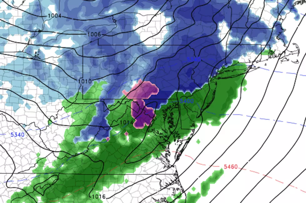
Similar to Thursday's storm, the brunt of the storm will occur right at the beginning. Bands of moderate to heavy snow will pass through northern and central New Jersey for a few hours from Monday midday through early afternoon. Meanwhile, just rain to the south.
As temperatures rise, we will see a further transition to plain rain — probably for all non-higher-elevation areas. And precipitation intensity (of both snow and rain) will dial back through the late afternoon and early evening hours.
So accumulations and impacts will be front-loaded, although slushy (and/or wet) conditions will linger through the Monday evening commute.
Accumulations
First of all, I do not see significant icing potential from this one. Any period of sleet or freezing rain will be brief, and part of an overall wintry mix. A nice change from the past few storm systems.
Model guidance maxes out at around 3 inches for NW NJ on Monday. Right on the edge of what I'd consider a "minor" and "moderate" snow event. If a heavier snow band becomes stagnant, or if it's even heavier than expected, I wouldn't rule out a few 4+ inch readings in that northwest corner of the state only.
Meanwhile, the Turnpike corridor north of about exit 6 or 7 could pick up a healthy coating, before precipitation changes over to rain. Not a guarantee that anything sticks, which is why 0" is a legitimate possibility here for the time being.
And coastal and southern New Jersey, you'll get some healthy rain out of this one. Upwards of a half-inch in the bucket by Monday evening. That relatively warm rain will help to melt any snow and ice that's still on the ground from the recent onslaught of winter storms.
Impacts
My biggest concern here — really my only significant concern — is the 3-ish hours of heavy snow right around and just after lunchtime on Monday. Visibility will become very poor in heavy snowfall. And road conditions will go down quickly. As long as you're not "out and about" in that window, and/or you're out of the "blue" zone on my map above, I think you'll fare OK.
Will schools opt for a full or early closing on Monday? Eh, maybe. The fact that the timing of the heavy snow will coincide with dismissal time is potentially problematic. Add to that the complication of COVID schedules and virtual learning considerations. I would not be surprised to see districts make the call, out of an abundance of caution. (And especially if an "advisory" serves as a trigger for such decision-making.)
Finally, it's important to note that a "flash freeze" after the storm Monday night is not a huge concern. Low temperatures will only bottom out around 30 degrees. That means most of the state will only see subfreezing temperatures for a few hours. In fact, South Jersey may not freeze at all — although patchy dense fog could become an issue instead, with all the ground-level moisture left from the rain.
No wind. No coastal flooding. No blizzard conditions. No icing. Just a little burst of snowy (and rainy) weather.
The Rest of the Week
We'll be treated to a warming trend through the middle of the week. The southern half of New Jersey may even break 50 degrees on Wednesday! There could be a few snow/rain showers along the way, along with substantial breaks of sunshine.
Models have been hinting at another coastal storm flying by the Jersey Shore late-week, around Friday-Saturday. As of right now, it's mainly a miss and we end up on the warm side of the storm — so we only have light rain in the forecast for now. However, it's still 5-6 days out, and absolutely worth watching in case the track wiggles our way.
Dan Zarrow is Chief Meteorologist for Townsquare Media New Jersey. Follow him on Facebook or Twitter for the latest forecast and realtime weather updates.


