
6 Things to Know About Tuesday’s Coastal Storm in NJ
As the center of Potential Tropical Cyclone 10 passes about 120 miles from New Jersey, we'll experience both weather and surf impacts.
From the National Hurricane Center
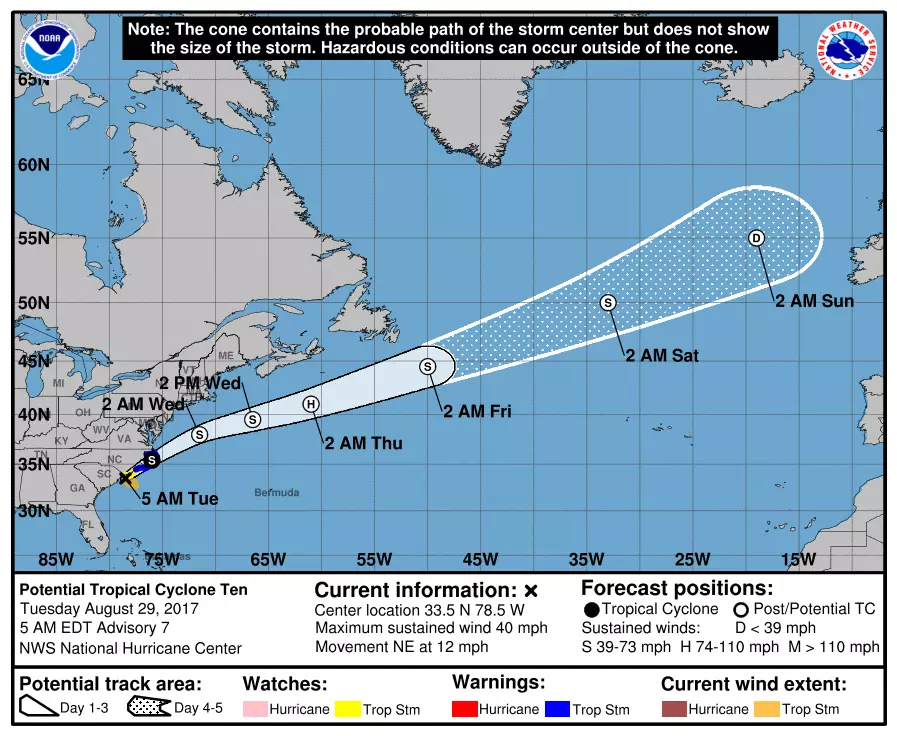
It's still not a tropical storm! (With good reason, as the storm's circulation remains sloppy.) As of Tuesday morning, Potential Tropical Cyclone 10 (which I'm also calling PTC 10, a coastal storm, and a tropical disturbance) is located off the Carolina coast. This fairly unorganized area of rain will continue to slide to the north-northeast, before taking a hard turn out to sea.
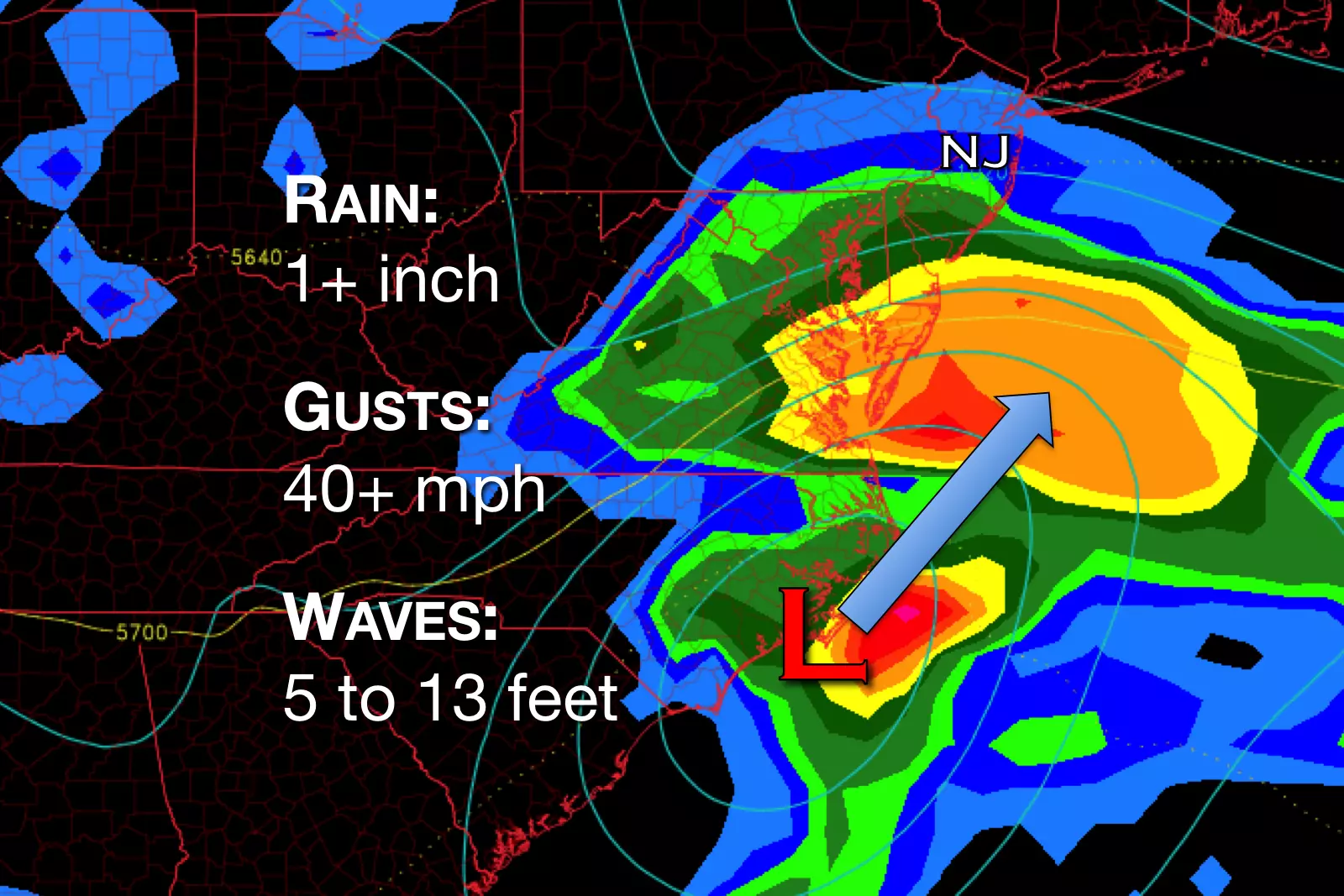
The latest forecasts show the storm track has wiggled a bit closer to New Jersey, so we've had to increase the expected rainfall totals, wind speeds, and wave heights. (Keep reading for details.)
Even though this is a relatively weak storm and even though it will not be a direct hit for New Jersey, Tuesday is going to be a downright nasty day. Wet, cloudy, and cool — thermometers will go nowhere, stuck in the 60s for most of the state.
Timeline
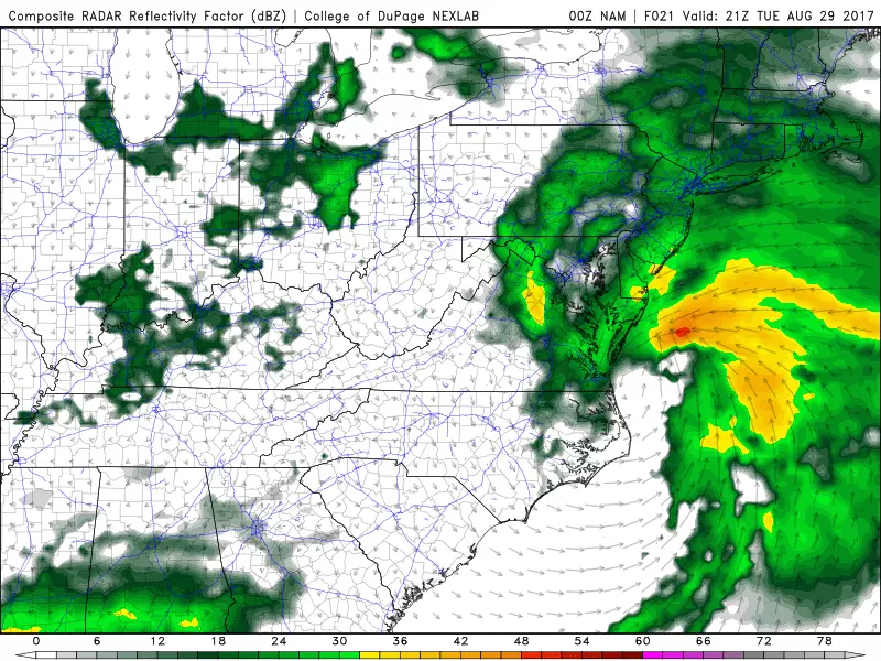
As of this writing, rain is already spreading northward through the Garden State, with heavier rain expected later on.
--Tuesday morning through 10 a.m. — rain spreads from South Jersey to North Jersey; wind increases to "breezy" then "gusty"
--Tuesday 10 a.m. to 8 p.m. — pockets of heavy rain south/east of the NJ Turnpike, bands of light to moderate rain otherwise
--Tuesday 8 p.m. — center of storm makes closest pass to New Jersey (about 120 miles south-southeast)
--Tuesday 8 p.m. to Wednesday 4 a.m. — chance of rain continues, tapering off substantially in the early morning hours
--Wednesday morning through 8 a.m. — a lingering shower chance, then decreasing clouds
Down the Shore

Surf was already rough across the Jersey Shore on Monday. And it will be even rougher throughout Tuesday, as brisk east-northeast winds push water toward the Garden State.
--Wave Heights — 5 to 13 feet
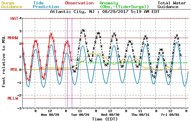
--Storm Surge — 1 to 1.5 feet
--Coastal Flooding — not a huge concern, but there will likely be minor flooding issues along tidal waterways at the times of high tide (i.e. in the "usual" spots)
--Bottom Line — stay out of the ocean and never attempt to drive, walk, or swim through flooded areas
Rain
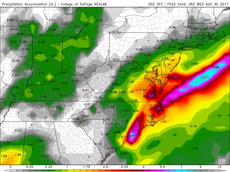
This storm's rainfall forecast has been quite muddled, as models flip-flopped between "pretty dry" and "very wet" solutions. We'll ultimately land somewhere in the middle, with bands of moderate to heavy rain likely for the area south and east of the NJ Turnpike (especially in NJ's coastal counties).
--NW New Jersey (Sussex, Warren counties) — hardly anything, probably less than a tenth of an inch of rainfall
--North and West of the NJ Turnpike — rainfall totals generally between a quarter-inch and half-inch
--South and East of the NJ Turnpike — rainfall totals may exceed an inch, with ponding on roadways and minor flash flooding possible
--Along the Coast — rainfall totals may approach 2 inches or more, depending on exactly where the heaviest downpours set up
Wind
PTC 10 is not an incredibly strong storm, so wind damage is not an incredibly high concern. Still, gusty winds may make driving difficult at times, especially as it further lowers visibility in areas of rain. And isolated or scattered power outages and property damage will be possible too.
--Cape May County — gusts to 40-45 mph possible
--The rest of the Jersey Shore — gusts to 35-40 mph possible
--Inland New Jersey — gusts to 25-30 mph possible
The Extended Forecast
As the coastal storm kicks further and further out to sea, we should see rapid improvements in the weather picture Wednesday morning. Following early showers, skies will clear at least partially by lunchtime. It will turn into a pleasant day, with high temperatures recovering to the upper 70s. Rough surf may continue to be a problem.
A nice warmup is in the cards for Thursday, as highs return to the lower to mid 80s across most of the state. We'll see a nice mix of sun and clouds. A shower will be possible from mid-afternoon onward, as a cold front sags into New Jersey.
That front will deliver a much cooler and drier air mass for Friday. It will be a sunny, but breezy, day with high temperatures in the lower to mid 70s. Another taste of Fall.
The Labor Day Weekend forecast contains some good news and bad news. The holiday weekend looks to be bookended by pleasant weather on Saturday and Monday, with a shot of some on Sunday. (That rain will be the decimated remnants of Harvey — we'll have to see how residual tropical moisture plays into rainfall intensity and totals.) Temperatures will moderate to the seasonable upper 70s to mid 80s through the weekend.
Dan Zarrow is Chief Meteorologist for Townsquare Media New Jersey. Follow him on Facebook or Twitter for the latest forecast and realtime weather updates.
More From SoJO 104.9 FM
