
Monday NJ weather: Much-needed rain, strong thunderstorms possible
The Bottom Line
As we begin a new week - the last full week of spring, by the way - we are falling into a much more typical June weather pattern. On average, this is our 3rd wettest and 3rd warmest month of the year. And we're finally going to get a taste of that, with several days of 80-degree temperature and sticky humidity. And finally some rain.
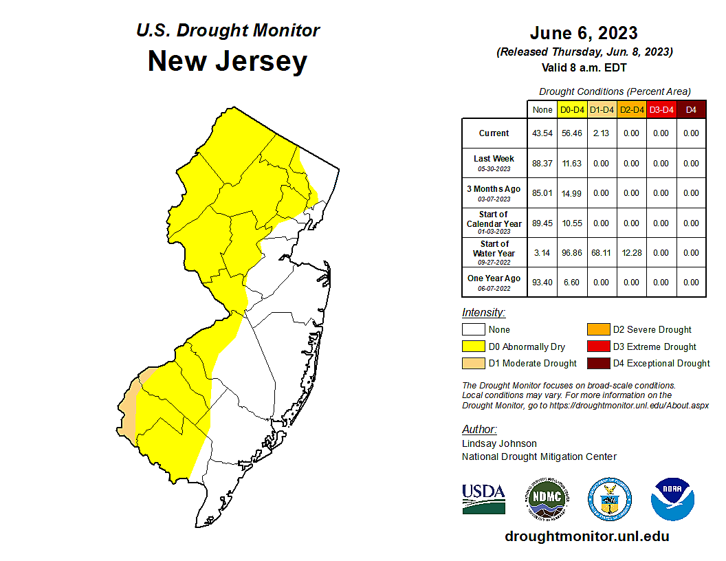
The last six weeks have been very dry. Since the beginning of May, there has been only one day with substantial, widespread rain in New Jersey: May 20th. A few other days featured spotty showers and thunderstorms.
So we need a good soaking here, to ease wildfire and drought concerns. I am confident everyone in New Jersey will pick up at least a quarter-inch of rain. And some spots could see over an inch of total rainfall.
Through the rest of the week, we will alternate pleasant and unsettled weather days. Tuesday and Thursday look good. Wednesday and Friday will be iffy at times.
I am also happy to report there are no smoke or haze concerns in New Jersey's forecast. The worst impacts from the Canadian wildfires will shift to the northern plains this week, around Minnesota and North Dakota.

Monday
Rain, glorious rain. Monday's rain will play out in two rounds.
Round 1 is a batch of showers bubbling up from the southwest Monday morning. Light and brief, and not necessarily affecting everyone.
The middle of the day will be mostly cloudy, breezy at times, and increasingly humid. Temperatures will rise from upper 60s in the morning to upper 70s by the afternoon.
The 'main event' of Monday's storm system is an approaching cold front, which could fire off thunderstorms along the western edge of NJ starting around 2 p.m. Rain will become more widespread and drift east through dinnertime, reaching the coast around 6 or 7 p.m. Storms will then pulse down and exit by around 10 p.m. to Midnight.
There are some minor alarm bells to be rung regarding stronger storm cells that may develop. Pockets of heavy rain are possible, especially from the initial burst of storms to the northwest. In addition, through the afternoon, strong to severe thunderstorms could produce gusty winds and small hail. Best chance for that would be in southern New Jersey, where temperatures will be warmest and the air most unstable.
Again, despite the potential for hazardous weather, despite putting outdoor plans in jeopardy, despite the murky sky and high humidity... we need this rain.
Skies will slowly clear Monday night, especially after Midnight. Humidity will start dropping too. It looks like thermometers will bottom out around the 60-degree mark.
Tuesday
New Jersey flips right back to dry weather for Tuesday. It should be a pleasant day from start to finish, especially as humidity levels fall back again too.
Look for a mix of sun and clouds Tuesday, with a noticeable westerly breeze. High temperatures will shoot for about 80 degrees. The chance of rain on Tuesday is negligible.
Wednesday
Another unsettled weather day. But do not fear, rain will not be an all-day thing.
At the moment, I favor scattered showers and thunderstorms around the Garden State Wednesday afternoon. Another quick hit of rain. Otherwise, skies will be partly sunny. And high temperatures still seasonably warm, in the upper 70s or so.
Thursday
Technically, behind Wednesday's cold front, we'll be under the influence of a new air mass and northwesterly winds on Thursday. But all that will do is clear out the skies and allow for another warmup.
I'm optimistically calling Thursday mostly sunny, with highs in the lower 80s. Once again, pleasant, summerlike, and dry.
Friday & Beyond
Friday is another potentially wet day, especially in the morning. Highs should hover in the 70s.
Long-range models favor a mainly dry Father's Day Weekend at the moment. Highs will mainly reach the 80s, under scattered to broken clouds. We may have to talk about another rain chance (the fourth in a week!) coming up late Sunday.
No luck with zucchini? Try these great tips for NJ garden success
Dan Zarrow is Chief Meteorologist for Townsquare Media New Jersey. Follow him on Facebook or Twitter for the latest forecast and realtime weather updates.
A look back at the NJ Garden State Parkway token
More From SoJO 104.9 FM


