Jersey Shore Report for Monday, February 1, 2021
Advisories
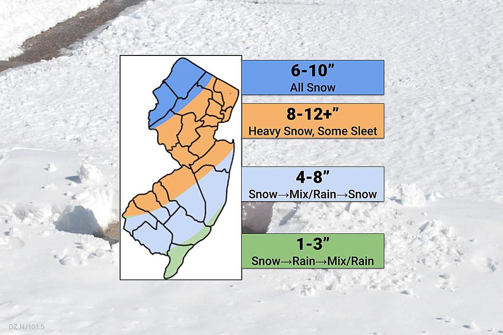
A Winter Storm Warning, a High Wind Warning, and a Coastal Flood Warning are in effect as a powerful nor'easter passes by the Jersey Shore Monday and Tuesday.
At the Shore
Current conditions and forecast as of Monday morning
| Air Temperature | 31° - 42° |
|---|---|
| Winds | From the Northeast 30 - 43 mph (Gust 55 mph) 26 - 37 knots (Gust 48 knots) |
| Waves | 9 - 16 feet |
| Rip Current Risk | High |
| Ocean Temperature | 35° - 39° (Normal 35° - 37°) |
| Sunrise/Sunset | 7:05am - 5:21pm |
| UV Index | 0 (Low) |
Tide Times
| SANDY HOOK Sandy Hook Bay | High Mon 10:08a | Low Mon 4:39p | High Mon 10:50p | Low Tue 4:55a | |
| LONG BRANCH Atlantic Ocean | High Mon 9:42a | Low Mon 4:03p | High Mon 10:24p | Low Tue 4:19a | |
| MANASQUAN INLET Atlantic Ocean | High Mon 9:56a | Low Mon 4:15p | High Mon 10:38p | Low Tue 4:31a | |
| SEASIDE HEIGHTS Atlantic Ocean | High Mon 9:38a | Low Mon 4:07p | High Mon 10:20p | Low Tue 4:23a | |
| SEASIDE PARK Barnegat Bay | Low Mon 8:11a | High Mon 1:48p | Low Mon 8:44p | High Tue 2:30a | |
| BARNEGAT INLET Barnegat Bay | High Mon 9:57a | Low Mon 4:38p | High Mon 10:37p | Low Tue 4:48a | |
| MANAHAWKIN BRIDGE Manahawkin Bay | Low Mon 7:45a | High Mon 12:55p | Low Mon 8:18p | High Tue 1:37a | |
| LITTLE EGG INLET Great Bay | High Mon 10:50a | Low Mon 5:11p | High Mon 11:27p | Low Tue 5:22a | |
| ATLANTIC CITY Atlantic Ocean | High Mon 9:43a | Low Mon 4:12p | High Mon 10:19p | Low Tue 4:25a | |
| OCEAN DRIVE BRIDGE Townsends Inlet | High Mon 10:25a | Low Mon 4:39p | High Mon 10:55p | Low Tue 4:52a | |
| WILDWOOD CREST Atlantic Ocean | High Mon 9:56a | Low Mon 4:17p | High Mon 10:27p | Low Tue 4:32a | |
| CAPE MAY Delaware Bay | High Mon 10:58a | Low Mon 5:12p | High Mon 11:27p | Low Tue 5:28a |
Marine Forecast
From the National Weather Service, Mt. Holly
STORM WARNING IN EFFECT THROUGH THIS EVENING
TODAY: NE winds 30 to 40 kt with gusts up to 55 kt. Seas 10 to 15 ft, building to 13 to 17 ft this afternoon. Rain. Vsby 1 to 3 NM, decreasing to 1 NM or less late this morning. Seas 10 to 15 ft dominant period 9 seconds, building to 13 to 17 ft dominant period 10 seconds this afternoon.
TONIGHT: NE winds 30 to 35 kt with gusts up to 45 kt, becoming N 25 to 30 kt with gusts up to 40 kt in the late evening and overnight. Seas 12 to 17 ft, subsiding to 9 to 14 ft after midnight. Rain until early morning, then rain or snow likely late. Vsby 1 to 3 NM. Seas 12 to 17 ft dominant period 10 seconds, subsiding to 9 to 14 ft dominant period 10 seconds after midnight.
TUE: N winds 20 to 25 kt with gusts up to 30 kt. Seas 8 to 11 ft, subsiding to 6 to 9 ft in the afternoon. Rain or snow likely. Vsby 1 to 3 NM. Swell mainly from the NE with a dominant period of 9 seconds.
TUE NIGHT: NW winds 20 to 25 kt with gusts up to 30 kt. Seas 6 to 8 ft, subsiding to 5 to 6 ft after midnight. Rain or snow likely early in the evening, then a chance of showers late in the evening. A chance of snow showers in the late evening and early morning. Vsby 1 to 3 NM. Swell mainly from the NW with a dominant period of 5 seconds in the evening.
WED: NW winds around 20 kt with gusts up to 30 kt. Seas 4 to 6 ft.
WED NIGHT: NW winds around 20 kt with gusts up to 30 kt. Seas 3 to 5 ft.
THU: NW winds 15 to 20 kt, becoming W 10 to 15 kt in the afternoon. Seas 3 to 4 ft.
THU NIGHT: SW winds 10 to 15 kt. Seas around 3 ft. A chance of rain and snow showers after midnight with vsby 1 to 3 NM.
FRI: SW winds 15 to 20 kt. Seas 4 to 6 ft. A chance of showers. Vsby 1 to 3 NM in the morning.
FRI NIGHT: W winds 15 to 20 kt. Seas 4 to 6 ft. A chance of showers in the evening.
Plan Your Trip
Data on this page amalgamated from several sources, including the National Weather Service (weather), National Ocean Service (tides), U.S. Naval Observatory (sun), and the U.S. Environmental Protection Agency (UV index).
More From SoJO 104.9 FM