
Latest Hermine Forecast: Good News and Bad News for NJ
The center of Hermine will stay well east of the Garden State, limiting heavy rain and gusty winds, but rough surf will be a big problem for most of next week.
Here are your Hermine headlines as of 6 a.m. Friday, September 2, 2016...
Good News: Off-shore Track
Models are coming into better agreement on this Friday morning regarding the track of Hermine, and it's partially good news for New Jersey. It looks like the center of the storm will ultimately stay well east of New Jersey. That means we'll be right on the edge of the weakest part of the storm - great news for avoiding the heavy tropical deluges and the potentially damaging winds.
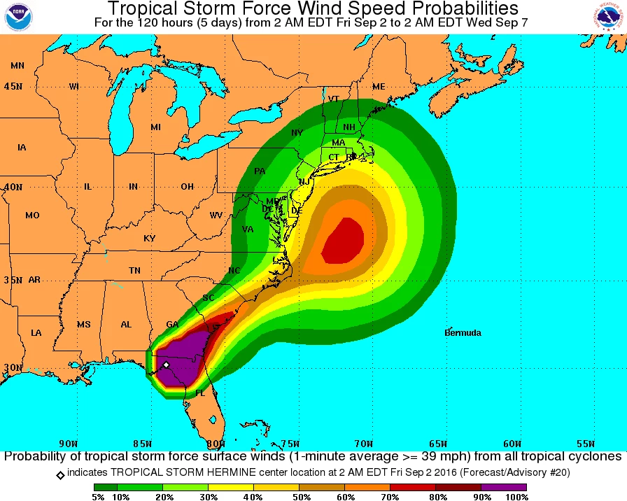
Here's the 5 a.m. advisory for newly downgraded Tropical Storm Hermine...
Both the GFS and NAM models keep most (if not all) of Hermine's rain off the coast. It's a very close call - I don't want to rule out the chance for a few heavy bands of rain moving on-shore, maybe totaling 3 inches if it really comes down hard. As you might guess, the best chance for heavy rain (2+ inches) will be along the coast.
At the very least, we'll pick up a stiff breeze throughout the weekend all across New Jersey. Stronger winds are possible, with potential gusts to 40 or 50 mph. That's fierce enough to bring down trees and power lines, make driving difficult, and blow lawn furniture around. Again, the winds will be strongest along the Jersey Shore.
Are you getting the sense that this storm will only be a big headache right along the coast? Sigh, keep reading...
Bad News: Coastal Concerns
While we've trended far away from the "worst case scenario" forecast for rain and wind, the coastal concern continues. We've known all along New Jersey's coastline would be battered by rough surf and strong rip currents. Beach erosion and some coastal flooding were always on the table.
However, as the storm track above shows, the situation has worsened, as Hermine is forecast to sit just off the Jersey Shore from Sunday through Wednesday (at least). It will sit and spin, spitting east-northeast winds toward the Jersey Shore. That on-shore flow will keep waves and water perilously high, well beyond the Labor Day Weekend.
The reason for this odd stagnant track is twofold: a strong area of high pressure over New England will block the storm's northward progression, and a lack of a steering mechanism (such as a front) that would kick the storm eastward out to sea.
I think the storm needs to get a little closer before we give a detailed surge forecast. As the tide prediction graph for Atlantic City shows, a rise of 3-4 feet will be possible during Sunday evening's high tide. That's certainly enough to flood low-lying areas - the "usual" spots.
Tropical Storm Watch
As of this writing, the National Hurricane Center continues a Tropical Storm Watch for the U.S. East Coast from Duck, North Carolina to Sandy Hook, New Jersey. That includes coastal portions of Monmouth, Ocean, Burlington, Atlantic, and Cape May counties.
A Tropical Storm Watch means tropical storm conditions (heavy rain, damaging wind, and rough surf) are possible within 48 hours. This watch may be upgraded to a warning as the storm draws near.
Timeline
Friday: Nice and dry, with most high temperatures in the lower 80s. Clouds from the outer edges of Hermine will push into South Jersey Friday afternoon. The ocean is already angry, with rough surf and a moderate risk for dangerous rip currents.
Friday Night: Still dry and comfortably cool, with lows in the 60s.
Saturday: To start, skies will be cloudy, and we pick up a stiff breeze ahead of the storm. You might squeeze out a mostly dry Saturday, especially the further north and west you are. Meanwhile, rain looks to begin along the south coast by Saturday afternoon.
Saturday night to Sunday: Prime time for Hermine's impact on New Jersey. It will get windy across most of the state, with gusts to 50 mph. Bands of heavy rain are possible, especially along the coast, with potential rainfall totals up to 3 inches. (It is wholly possible that the western half of New Jersey stays completely dry this weekend.) Coastal threats including rough surf, rip currents, beach erosion, and coastal flooding will peak Sunday.
Labor Day Monday: Rain tapers off to showers, and winds slowly start to subside (although gusts to 40 mph are still possible). By Monday afternoon, we could see a few breaks of sun inland.,
Tuesday to Wednesday: As Hermine's remnants sit just off the Jersey Shore, water will continue to pile up and slam against the coast. Wave will remain high, the surf will remain rough, and coastal flooding may continue to occur at the times of high tide.
More From SoJO 104.9 FM


